Third Graders Hop from Maine to California—Literally!
In their current social studies unit, third graders are learning about landforms, bodies of water, and the geography of the United States.
And in their current PE unit, they’re covering the same subject matter. That’s right—a combination of pushups, hopping, running, and crab-walks on the playground is reinforcing the students’ newly learned geographical knowledge!
When the curriculum recently covered bodies of water, class teacher Heather Schierholz and PE teacher Jane Harrison led the students on a hike to Lasky Pond to observe firsthand the role and characteristics of lakes and ponds and their surrounding environment. Then the group walked back along Clayton Road to the home of a Principia family and had a fun swimming session in their pool! While hiking both ways, the students were introduced to east, west, north, and south and used a compass to determine directions.
“What is so exciting about cross-curricular work is how we, as teachers, can provide creative, fun, experiential avenues for the students to learn . . . [and] to see connections throughout their school day and learning experience,” Harrison says. She and Schierholz agree that students retain new information better when they are “activity-engaged.”
The class then moved on to the study of the United States, including learning the names and locations of all 50 states and state capitals. A couple of weeks ago, they learned more about the Midwest and the important role of the Mississippi river. They took a riverboat ride, observing the differences between the Illinois and Missouri sides of the river, and then went up the St. Louis Arch to view both states from 630 feet above ground.
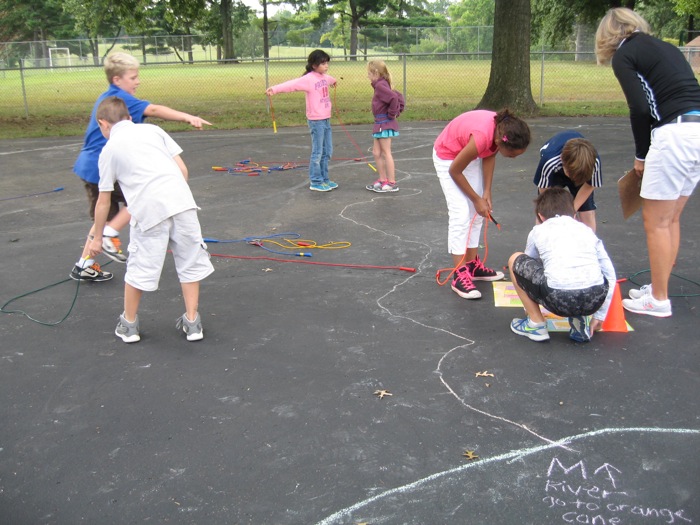
After that, the timing was perfect to try yet another combination of geography and PE! On a paved section of the Lower School playground, a Middle School student helped Harrison outline a large map of the Lower 48 in chalk, bisected by the north-south course of the Mississippi. Once the children had warmed up by running lengths on the playground, they congregated in the Gulf of Mexico.
“Now, run to the farthest northwest corner of the U.S.,” instructed Harrison. After a little bit of initial confusion—only natural, since they were used to viewing much smaller maps hung up on a wall—the students crowded around what would be the greater Seattle area. “Now let’s do 12 pushups in the state of Washington!” Done.
Next, they had to find the farthest southeast corner of the U.S. Once there, it was time for crab pushups. Then they had to figure out and name the northeastern-most state. Finally, they hopped all the way from Maine to California . . . quite a challenge, as it’s a long way on one foot!
After all this activity, it was time to slow things down a bit. Working in groups of two or three, the students were given several lengths of jump ropes and asked to outline the borders of different states along the west bank of the Mississippi River. They could refer to printed maps, but it took a considerable amount of teamwork, patience, and an eye for detail as they tried to follow the contours of states such as Arkansas, Missouri, and Iowa. Louisiana was particularly challenging, as a small section of it stretches east of the Mississippi, and the coastline is rather indented in places!
But gradually—to cries of “I get it now!” and “We’ve done it!”—the students successfully completed their task and reinforced their knowledge of geography. (The following day, they returned to the playground map and “traveled” from state to state inside the jump ropes, learning their placement along the river.)
“Working together with Jane has enriched our program so much,” says Schierholz. “These students are experiencing what they are learning and therefore remembering it and wanting to do more.”
“The students are having fun while they are learning,” agrees Harrison, adding, “As a teacher, I love it, too!”